
Logistics
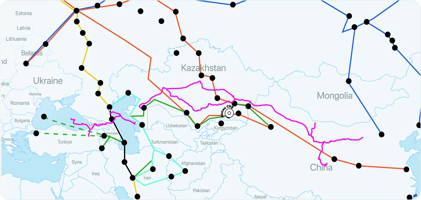
Strategically located at the heart of Almaty Region in southeastern Kazakhstan, between the cities of Almaty and Konaev, Alatau possesses immense logistical potential.
Its location along the A3 highway (Almaty – Ust-Kamenogorsk), a key transport artery leading to the International Centre for Border Cooperation “Khorgos,” opens wide opportunities within the framework of the New Silk Road initiative.
Its advanced transport network enables seamless connectivity with major logistics centers across southern (Shymkent, Taraz, Turkestan), eastern (Semey, Ust-Kamenogorsk, Pavlodar), and central Kazakhstan (Astana, Karaganda).
Railway Infrastructure
Alatau’s public transportation network will be developed through both rail and surface transit systems, structured into the following components:
- Regional Lines. Long-distance services will span 126.6 km within city boundaries. A major railway station will be built in Alatau, serving international, intercity, and suburban passenger traffic.
- Agglomeration Lines. High-speed services will link Almaty – Alatau – Konaev, along with express lines to Almaty International Airport and the future Alatau International Airport. The total length of agglomeration lines within Alatau will be 53.5 km. Average distance between stations will be 6.3 km; the operating speed will be 60–70 km/h. The peak passenger flow on the busiest section of the line is expected to reach approximately 65,000 passengers per day in each direction. The total daily ridership is projected at around 150,000 passengers.
- Urban Lines (LRT). Three light rail transit (LRT) lines are planned within Alatau. The busiest sections are expected to serve up to 55,000 passengers per day in one direction.The total daily ridership is estimated at approximately 200,000 passengers.
- Konaev City. The Zhetygen – Kazybek Bi railway section is part of the transcontinental transport corridor connecting Western Europe and Western China. A large sorting station will be constructed along the segment connecting the new Alatau Airport with the city of Konaev.
Air Transport

The International Airport Alatau is planned to be built along the western boundary of the city. Designed throughput capacity - 15 million passengers per year. By 2050, the expected passenger traffic may reach up to 40 million passengers annually. This growth will be supported by the region's immense potential: about 2 billion people live within a five-hour flight radius from the Almaty agglomeration.
Thanks to the strategic proximity of the airport and the new railway terminal, the largest international transport hub in the region will be formed.
The project provides for:
- 1,500 hectares allocated for the airport
- 750 hectares allocated for the logistics zone
The airport will become an international aero-hub featuring an integrated dry port, a multifunctional complex with cultural and entertainment facilities, and recreational zones. Convenient access to the airport will be ensured through various modes of public transportation, including airport express lines from Almaty and Konaev.
Road Infrastructure

The layout of Alatau’s main roads will represent a network of straight streets intersecting at right angles. The road planning will take into account the future development of transportation routes throughout the Almaty agglomeration.
The city’s road network will consist of:
- Three meridional highways (north–south)
- Six latitudinal highways (west–east)
Among them, the most notable are the existing Almaty – Ust-Kamenogorsk highway, the planned Almaty – Taldykorgan – Ust-Kamenogorsk road, the agglomeration ring road BAKAD, and the Almaty – Shelek – Khorgos route.
The street and road network will encompass all categories of urban and rural roads. Approximately 80 transport interchanges are planned on the high-speed highways.